
Share


Traceability and environmental monitoring serve distinct but complementary purposes. When integrated, they provide a view that neither can achieve on its own.
Traceability is the animal’s timeline, recording the properties it has passed through, the dates, and the movement documents involved. In other words, it answers the question “where did this animal come from?”
Environmental monitoring, in turn, involves tracking the quality of the territory. It seeks to assess whether each farm in that timeline was—and remains—in socio-environmental compliance. It answers the question: “is the land through which this animal passed free from deforestation?”
Integrating these two layers makes it possible to identify the risk of “cattle laundering” — when an animal raised in an area with a history of deforestation is transferred to a compliant farm before slaughter, erasing the illegal trail. With individual traceability integrated with environmental monitoring of all properties involved in the production cycle—breeding, rearing, and finishing—this window of risk is closed.
The Minerva Foods Individual Traceability Protocol operates on precisely this logic: it individually identifies each animal using official records, cross-references its movement history with the socio-environmental monitoring of all farms involved, and issues a compliance certification document, prepared by certification bodies accredited by MAPA, before any shipment.
Browse the content:
- The role of monitoring in cattle farming
- How the industry transforms public data into operational intelligence
- Integrating monitoring and traceability: strategic and urgent
- From obligation to business intelligence
The role of monitoring in cattle farming
Monitoring a property in the context of cattle farming means collecting, updating, and analyzing territorial and socio-environmental information according to defined criteria. This may include verifying:
- deforestation polygons—areas outlined on digital maps indicating where vegetation was cleared;
- areas embargoed by environmental agencies—locations where activities have been suspended because of identified environmental violations;
- vegetation-clearing permits—documents issued by the environmental agency authorizing the legal removal of vegetation in a specific area;
- overlaps with Indigenous lands and conservation units—when a property’s boundaries fully or partially coincide with legally protected areas;
- registration and status in the Rural Environmental Registry—indicating whether the rural property is registered in the system and whether its registration is active, pending, or subject to an irregularity;
- the presence of employers on public lists related to conditions analogous to slavery—indicating whether individuals or companies connected to the supplier have been held responsible for this practice;
- other criteria established in applicable purchasing policies and protocols.
No single database provides all these answers. Monitoring therefore depends on cross-referencing different sources, technically interpreting the results, and defining procedures for addressing alerts, inconsistencies, and potential noncompliance.
Monitoring the environment in the context of cattle farming therefore means continuously tracking what happens to the territory and the people who sustain production. In essence, it is the systematic collection, analysis, and updating of data on land use and land conditions over time.
In Brazil, this work relies on a robust, internationally recognized public database built over decades by research institutes and government agencies. Four systems stand out in structuring this framework:
- PRODES, a benchmark for public policy and credit allocation
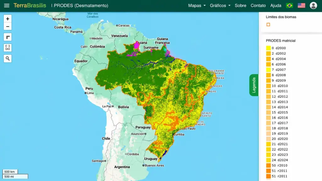
The Amazon Forest Satellite Deforestation Monitoring Program, conducted by the National Institute for Space Research (INPE), calculates the official annual deforestation rate. It serves as the benchmark for public policies, international agreements, and court decisions. The data is publicly available through the TerraBrasilis platform and has increasingly been used in rural credit decisions—as of April 2025, financial institutions operating under the Harvest Plan began consulting it before releasing financing.
- DETER, the deforestation radar

The Real-Time Deforestation Detection System, developed by INPE, issues alerts on changes in forest cover at near-real-time intervals. It is the operational tool used by the Brazilian Institute for the Environment and Renewable Natural Resources (IBAMA) for enforcement. While PRODES measures accumulated deforestation with high precision, DETER functions as an alert radar—with lower resolution but much greater speed. DETER alerts, however, should not be interpreted in isolation as an official deforestation rate or as a definitive conclusion regarding the legality of a particular occurrence. They serve as tools for prioritization and investigation.
Although full access to the platform is restricted to public servants and enforcement agencies, the general public can access the Warning Map on the TerraBrasilis website and reports and consolidated data through the Pamgia platform.
- CAR, the official registry of rural properties
A fundamental basis for geospatial analyses, the Rural Environmental Registry is the georeferenced registration of each rural property, officially declaring its boundaries, legal reserve areas, and permanent preservation areas. It is the anchor for the environmental compliance of properties and the starting point for any socio-environmental risk analysis of suppliers, as well as the first step in the environmental regularization process. However, registration alone does not prove environmental compliance, ownership of the area, or the absence of overlaps. The information must be analyzed and validated by the competent authorities and cross-referenced with other sources.
- MapBiomas, the integrated map of Brazil’s biomes
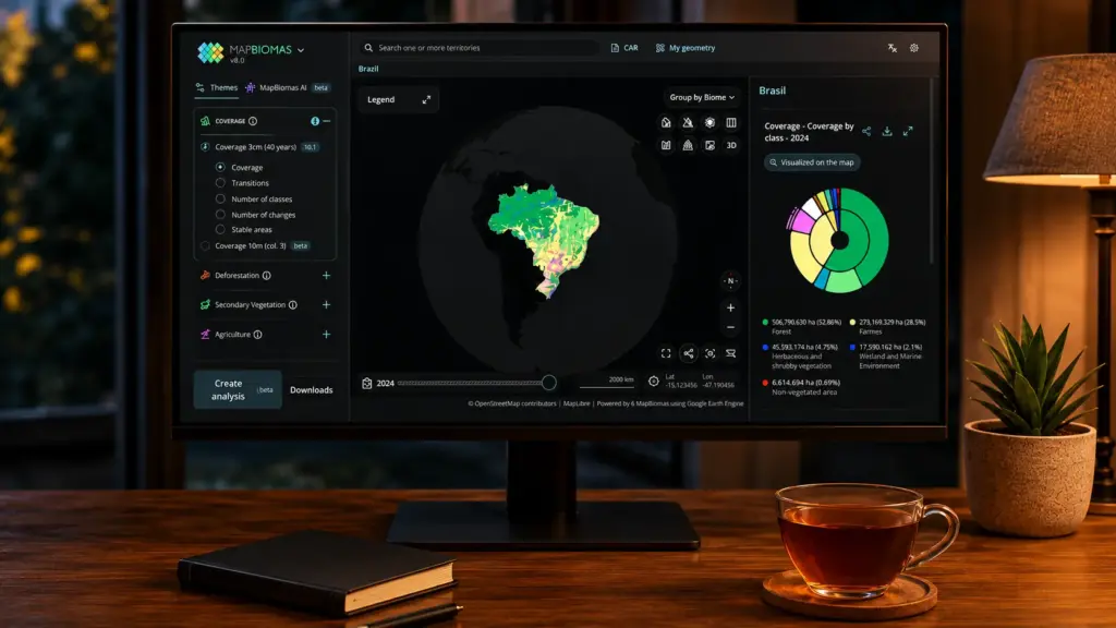
A collaborative initiative that produces annual land-use and land-cover mapping across all Brazilian biomes. It goes beyond deforestation, recording pastureland, cropland, native vegetation, bodies of water, and other categories. MapBiomas Alerta aggregates and validates alerts from multiple systems—including DETER and GFW—using high-resolution imagery, consolidating deforestation alerts with methodological rigor. The system has been recognized by the National Council of Justice as valid evidence in environmental proceedings. Even so, an alert does not automatically amount to a legal conclusion of illegal deforestation. Dates, authorizations, territorial boundaries, documentation, and other elements applicable to the case under analysis must be considered.
AgroBrasil + Sustentável, an integrated data platform via Gov.br
A recent initiative seeks to directly address the limited integration between databases: the AgroBrasil + Sustentável Platform, launched in December 2024 by the Ministry of Agriculture in partnership with Serpro. Free, voluntary, and accessible through Gov.br, the platform brings together data from CAR, IBAMA, ICMBio, and PRODES, among others, generating a property socio-environmental verification report that primarily empowers rural producers by placing consolidated information about their property at their disposal.
The platform already represents progress in connecting information, and the proposal is to develop it into a single, internationally recognized repository, complementing the risk-management systems, purchasing protocols, and additional checks adopted by companies, certification bodies, and financial institutions.
How the industry transforms public data into operational intelligence
Raw public data is one element of the equation. Companies that can cross-reference, process, and interpret these databases at an operational scale are the ones that turn information into action. In the beef-protein sector, this represents a paradigm shift: socio-environmental monitoring is no longer merely a compliance obligation and has become a business-intelligence function. In practice, this process involves four technological layers:
1. Cross-referencing databases: combining CAR, DETER, PRODES, MapBiomas, and others to determine whether a property has deforestation alerts, land irregularities, or overlaps with protected areas.
2. Geotechnology and spatial intelligence: using satellite imagery, georeferenced polygons, and territorial analysis to accurately map the environmental conditions of each supplying farm.
3. Proprietary monitoring systems: developing internal platforms that automate socio-environmental compliance analyses and integrate data from multiple sources in operational time.
4. Democratizing the tool: sharing the technology with suppliers themselves so they can check their supply chain before marketing cattle.
The result of this integration is that data ceases to be merely informative and becomes a strategic asset with concrete applications in operations: socio-environmental risk management, the selection and blocking of noncompliant suppliers, operational purchasing decisions, the production of third-party-auditable ESG reports, and compliance with regulatory requirements in international markets.
| How Minerva Foods operates this model in practice Minerva Foods was a pioneer in expanding geospatial monitoring to 100% of direct suppliers across all Brazilian biomes—Amazon, Cerrado, Pantanal, Caatinga, and Atlantic Forest—in 2024, bringing forward by six years its original target of reaching 100% monitoring of direct suppliers in all countries where it operates in South America (Brazil, Paraguay, Colombia, Argentina, and Uruguay). Part of this success is attributable to SMGeo Prospec, developed in partnership with Niceplanet Geotecnologia. It allows producers to consult socio-environmental information about their properties and potential animal suppliers. The tool expands direct suppliers’ management capabilities, but it should not be presented, in isolation, as a guarantee of complete traceability. Its scope depends on the information available, the records entered, and the quality of the databases consulted. As part of a broader strategy involving technology, protocols, controls, public policies, and multisector engagement, it enables detailed geospatial research, with access to the historical records and socio-environmental analyses of farms. The company distributed more than 3,000 free vouchers so suppliers could check their own supply chains before each sale. Although monitoring indirect suppliers remains one of the cattle chain’s main structural challenges, Minerva Foods adopts a combination of approaches, including Individual Traceability, Full-Cycle, and Tier 1 Indirect Supplier protocols, risk analyses, controls integrated into internal processes, technical visits, and field checks (learn more in the article “From farm to slaughterhouse: how suppliers’ socio-environmental monitoring works”). This is because the availability of records, different production models, animal movements, and regional particularities mean that a single solution is not sufficient for all producers. Geospatial monitoring systems are therefore cross-referenced with official lists from IBAMA, the Ministry of the Environment, the Labor Secretariat, and CAR. Any irregularity detected automatically triggers the supplier’s suspension. The system undergoes annual audits conducted by the Federal Public Prosecutor’s Office, with 100% compliance results in the states of Pará, Rondônia, and Mato Grosso. Click here to learn about the complete case |
Integrating monitoring and traceability: strategic and urgent

The combination of traceability and environmental monitoring is no longer merely a competitive advantage. In markets such as the European Union, it has become a condition for market access.
This is because the European Union Deforestation Regulation (EUDR) establishes due diligence obligations for products related to certain commodities (including cattle), requiring a statement containing:
- evidence that production is not associated with deforestation occurring after December 31, 2020;
- verifiable information on compliance with the relevant legislation of the country of production;
- the geolocation of the establishments where the animals were kept;
- an assessment and, where necessary, mitigation of the risks identified.
This means exporters and producers must provide sufficiently structured and verifiable information to meet their obligations. The main obligations will become applicable as of December 30, 2026. Without this information, products may not be lawfully placed on the European market.
In Brazil’s financial sector, SARB Standard 026/2023 also reinforced this agenda by establishing guidelines for signatory financial institutions to incorporate illegal-deforestation risk management into credit operations involving cattle slaughterhouses and meatpacking plants. Its requirements include adopting traceability and monitoring mechanisms for direct and indirect suppliers, applying socio-environmental criteria, and periodically disclosing indicators. The standard demonstrates that the ability to show the origin and compliance of raw materials has also become part of financial risk analysis.
From obligation to business intelligence
The evolution of environmental monitoring in cattle farming is part of a broader movement: the transition from sustainability as a cost to sustainability as an asset. Well-structured environmental data, integrated with animal traceability and audited by third parties, delivers three simultaneous advantages.
The first is market access, as European and Asian buyers and financial institutions in capital markets begin to use environmental compliance as a selection criterion rather than merely a marketing tool. Decision-making support is another advantage: access to near-real-time territorial data makes it possible to anticipate supplier risks, optimize the purchasing chain, and respond quickly to deforestation alerts. Finally, companies that adopt this infrastructure before regulatory requirements take effect enter new markets with lower adaptation costs and greater credibility among auditors and buyers.
The next frontier is determining how this monitoring can be deepened, whether through new technologies such as remote sensing and artificial intelligence or through close engagement with the supply chain and in loco visits—a model that goes beyond data and builds the trust that no satellite can certify on its own.
- PRODES and DETER: strategic systems in the fight against deforestation — InfoAmazonia
- TerraBrasilis — platform for accessing PRODES and DETER data (INPE)
- PRODES as a strategic tool for rural producers — MartinsZanchet
- MapBiomas Alerta — clarification on methodology and legal validity
- MapBiomas Alerta — method and data sources
- Failures in rural credit monitoring and the need to integrate databases (CAR, DETER, PRODES, MapBiomas) — Softfocus
- AgroBrasil + Sustentável Platform — O Presente Rural
- AgroBrasil + Sustentável Platform — launched by Serpro/MAPA
- AgroBrasil + Sustentável Platform report as a compliance tool — Pecuária Sustentável
- Embrapa and the private sector in consolidating sustainable agriculture — Embrapa Portal
- Minerva Foods’ actions to combat illegal deforestation — Brazil Journal
- Minerva Foods launches SMGeo Prospec for rural producers — Portal DBO
- Minerva Foods’ position on traceability and monitoring — Repórter Brasil (2021)
- Minerva Foods’ position — Repórter Brasil (2024)
- Minerva Foods reaches 100% compliance in the Amazon Monitoring Protocol — Minuto MT
- Minerva Foods reaches 100% traceability in Colombia — Brazil Journal
- SARB Standard 026/2023 — Minerva Foods (Compliance report)
- EUDR — Regulation on deforestation-free products — European Commission